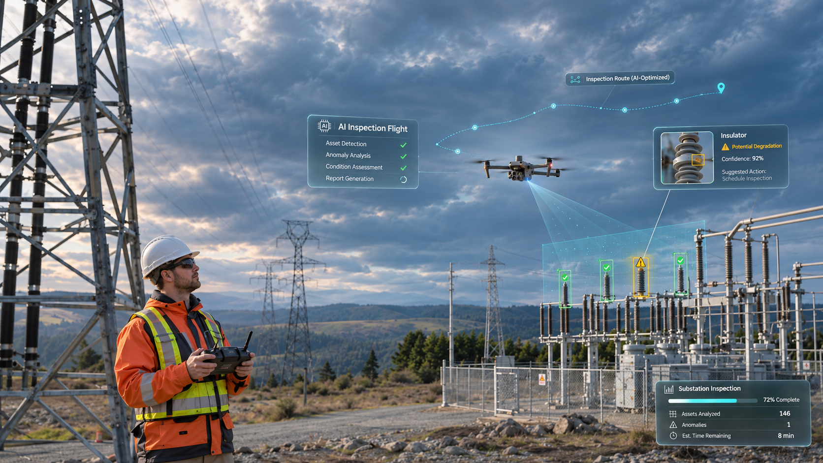
Say your crew is halfway through a substation inspection when the drone marks something odd near an overhead connection. It’s already found the object, kept it in frame and saved an image. There’s a neat little detection box on your screen.
Now, is that connection actually damaged? And does somebody need to shut the equipment down?
DJI launched the Matrice 5T on 5 November 2026, and it packs a lot into a compact enterprise aircraft: onboard AI, thermal and visible-light analysis, cloud-assisted target searches and automated patrol actions. DJI says the built-in models recognise more than 20 target types. Developers can load their own algorithms too. If your team runs repeat inspections, there’s plenty here worth a close look.
So how far does all that intelligence actually reach? You can ask the software to find a vehicle, highlight a hot area or go back to a suspicious section of blade. What it can’t do for you is decide what the evidence shows, whether the images are good enough or what action is justified. The easiest way to see where that line sits is to follow an inspection from take-off to the final maintenance decision.
What DJI Has Actually Put on the Matrice 5T
Hardware first. The aircraft carries a native 1280 × 1024 thermal camera, visible-light cameras, rotating LiDAR, millimetre-wave radar and omnidirectional vision sensing. DJI quotes up to 59 minutes of flight time, a standard take-off weight of 2,239 g and an IP55 ingress-protection rating. The published operating temperature range runs from −20°C to 50°C.
Note that these were measured under DJI’s stated test conditions, so you won’t necessarily see them on every job you fly.
The software is where things get more interesting. DJI is moving away from a fixed set of flight features and towards something closer to an open computing platform. It describes three connected capabilities, and each one does a different job.
Built-In Detection Works During the Flight
The Matrice 5T can identify over 20 types of target by using its thermal and visible feeds together. Vehicles, vessels and fires all show up in the company’s examples. Because the system highlights a target while you’re still on site, it’s a real help when a patrol covers a large area or the subject is hard to pick out on a small screen.
Keep the limits in mind, though. A recognised vehicle is only an object label, and a suspected fire is only an alert for you to go and check. Neither one adds up to a full site-safety assessment. DJI also hasn’t published a universal, independently validated accuracy rate for the Matrice 5T’s target library. Before you rely on automated alerts, ask for evidence that matches your own conditions.
How much heat does a rocket launch create? DJI Matrice 5T drone footage in two views: visible-light camera for the plume and ascent, thermal camera for how the heat spreads through the exhaust. Which view tells you more? #DJIMatrice5T #AIDrone https://t.co/u3YhjoYHm3
— DJI Enterprise (@DJIEnterprise) November 6, 2026
FlightHub 2 Adds Prompt-Based Search
Connect the aircraft to DJI FlightHub 2 and the Pilot 2 workflow lets you search in the cloud using a text or image prompt. In DJI’s example, a team asks for a particular kind of target and skips reviewing every frame by hand. DJI also describes AI patrol routes. You outline a search area, then tell the drone what to do when a defined target appears: hover, take photographs, record video or broadcast audio.
That should mean less time staring at a screen. It also raises a question for your operating procedure. Who checks a prompt’s result before it triggers a response? A vague search instruction could easily pick out the wrong object, especially in a crowded industrial yard.
Developers Can Add Specialised Models
The Matrice 5T supports third-party onboard algorithms and custom Pilot 2 plugins. DJI’s Intelligent Computing Platform lays out the developer process: you train a model locally, submit it for conversion or quantisation, then distribute it to the devices you choose. Mobile SDK, Payload SDK and Cloud API support are all listed in DJI’s product support guidance as well.
If you run an inspection firm, this is the part that opens doors. A developer could train software to mark missing roof tiles, particular corrosion patterns or visible insulator damage. Be clear with yourself and your clients, though, that these are custom projects you’d have to commission. None of them comes pre-installed as a Matrice 5T defect-detection function, and somebody still has to build the model, test it and keep it maintained.
Seeing an Object Is Different From Diagnosing a Defect
Computer vision is very good at tightly defined questions. Is there a vehicle in this frame? Where’s the circular gauge? Which images contain something that looks like a crack? Bounding boxes, labels and confidence scores handle that kind of task well.
An engineering diagnosis asks for more. Take a thin dark line on a wind turbine blade. It could be a crack. It could just as easily be dirt, a repair edge or the boundary of some protective tape. The software will highlight the pixels that look familiar, and then a specialist has to weigh up the material, the geometry, any previous repairs and what happens if the call is wrong.
Detection scores are especially easy to misread. Say your screen shows 0.92 beside the word “crack”. That number is a confidence score the model generated from its own training and calibration. It doesn’t mean there’s a 92% chance the blade is unsafe, and it tells you even less about repair costs or how long a component has before it fails.
It helps to split a useful inspection record into five stages. You find a candidate, check whether it’s a genuine defect, measure it, grade its severity and recommend a response. The Matrice 5T’s object recognition covers the earliest of those in some workflows. The later ones are different. They need suitable measurement methods, the asset’s history and an agreed assessment standard.
Keeping the stages apart has a practical payoff, because your reports get easier to defend. Your client can see which findings came from the machine, which ones were reviewed and where an engineer’s judgement came in.
Better Sensors Give AI More to Work With
Don’t skip past the cameras and sensors. Even excellent software struggles with poor input.
DJI’s native thermal resolution is 1280 × 1024, which works out at 1,310,720 detector pixels. A conventional 640 × 512 sensor has 327,680. That’s exactly four times as many thermal pixels.
There’s also an ultra-high-resolution thermal output of 2560 × 2048, or 5,242,880 output pixels. The native detector behind it is still 1280 × 1024. When you’re making technical comparisons, keep native sensor detail and processed image output in separate columns. And remember that flight distance, lens, thermal contrast and the size of the target still decide how much useful information reaches the detector in the first place.
What about flying at night? DJI quotes colour imagery down to 0.01 lux using AI low-light processing, and says the sensing system can support visual positioning at 0.5 lux. LiDAR can pick up certain power-line obstacles at distances of up to 32 metres at night, and radar gives you another sensing method when visibility is poor. All of that may help your crew keep a better view of complicated surroundings, within the conditions the manufacturer states.
That 59-minute flight time needs some context too. According to the published Matrice 5T specifications, DJI measured it in a controlled, no-wind environment, flying at roughly 9 m/s with no added payload until the battery hit 0%. You’d never fly a real job that way. Your plan has to allow for a landing reserve, the weather and any extra inspection passes.
One more number. DJI says the controller can work through 200 photographs in eight minutes to produce a local point cloud or 2.5D model. That’s handy when you’re planning a workflow. It doesn’t tell you how fast or how accurate any particular third-party inspection model will be.
What Happens When AI Meets Inspection Data
Launch demos are always polished, so it’s worth setting some research alongside them.
In a May 2026 comparison of five wind turbine blade inspection models, researchers reported 94% accuracy, 93% precision and 92% recall for EfficientNet-B7 on their test data. A YOLO model came in at 88% accuracy, 86% precision and 87% recall. Those results belong to that research setup, so please don’t treat them as performance figures for DJI’s new aircraft.
The same authors then looked at 100 failure cases from their best model, and this is the useful bit. They put 45% down to difficult imaging conditions such as blur, backlighting and shadows. Another 35% came from confusing visual patterns like dirt or tape, and the remaining 20% were small defects that were hard to resolve. Bear in mind that those percentages describe the failures they selected. They aren’t an overall failure rate across every blade inspected.
That breakdown shows you what a better camera can and can’t fix. Sharper imaging might help with a tiny defect that occupies too few pixels. It won’t clear away every confusing stain, and it can’t turn a badly exposed photograph into something fit for engineering sign-off. You still need a capture plan, and you still need the option to go back for another view.
Solar Research Shows the Cost of Missed Hotspots
A September 2026 research dataset from Bangladesh gives you another example. The researchers collected 50 original UAV samples across two rooftop solar sites, expanded them to 5,000 images through processing and augmentation, and trained a YOLO26s hotspot detector for 95 epochs. Their validation figures were 94.7% precision, 88.9% recall and 93.6% mean average precision at an intersection-over-union threshold of 0.5.
Sounds strong. Now look at the validation confusion matrix. It shows 488 correctly identified hotspot instances, 53 missed ones and 37 background areas wrongly flagged as hotspots. If your client expects every anomaly to be found before technicians climb onto a roof, those errors matter. And a dataset that started from only 50 original samples can only tell you so much about performance at a site it has never seen.
Finding a fault is only half the job. A separate 2025 study of aerial photovoltaic thermography found that fault detection held up at imaging distances up to roughly 80 metres in its experiments, while location accuracy became the bigger constraint. An accurate alert pinned to the wrong panel still sends your maintenance crew to the wrong place.
Wind Farms, Solar Parks and Power Lines Need Different AI
You’ll hear the word “inspection” used for all three industries. The evidence each one needs is quite different, though, and this is where a custom model and a capable pilot have to work together.
Wind Turbine Blades Need Context Across Inspection Cycles
A single blade survey can produce thousands of photographs, with overlapping views of the leading edge, trailing edge, pressure side and suction side. AI screening can group the likely defects and take a lot of the routine sorting off your hands. For your field team, the most immediate win may be simpler than that. They find out a particular blade section needs another close image before the aircraft lands.
Severity is a harder question, and it depends on much more than how a line looks. A specialist may need the defect’s dimensions, its location on the blade, how the material behaves, previous repair information and any sign that the damage has grown between inspections. A small mark near a critical region can deserve more attention than a large superficial stain somewhere else. It’s the asset records that give a finding its history.
An October 2026 offshore wind inspection review found that autonomous fault detection is still held back by limited real-world testing and training data. Offshore light, moisture and backgrounds throw up difficulties that controlled datasets rarely reproduce in full. The practical answer is to test the exact workflow on the kind of turbines you actually service.
Solar Parks Need Reliable Temperature Interpretation
On a solar site, the first useful job is often finding panels with unusual thermal patterns and tying each alert to a row and module number. An inspection algorithm can help with that localisation and with the initial sorting. Then it’s over to a trained thermographer, who decides whether the pattern points to a module fault, shading, soiling, a disconnected string or simply the operating conditions at the time.
Timing matters as well. A 2025 study of photovoltaic imaging parameters evaluated more than 38,000 thermal and RGB images across 21 flight configurations and four times of day, looking at changes in altitude, viewing angle, speed and solar position. Put those variables in your flight brief before you start comparing detection percentages from different projects.
On a solar park, then, AI is most useful for building a consistent inventory of anomalies. The engineering interpretation has to connect those thermal findings with irradiance, plant operation, electrical measurements and follow-up testing where it’s needed.
Power-Line Patrols Need Careful Separation of Flight Safety and Asset Findings
DJI says the Matrice 5T’s top-mounted LiDAR can lock onto certain power and ground wires to support lateral flight along a line. Treat that as a flight and capture feature. Detecting a broken strand, a loose fitting or an overheated connector is a separate inspection task, and it needs suitable imagery plus a verified detection method.
Wires can be hard to sense, too, when their orientation, background or material changes. DJI’s Matrice 5T FAQ lists test examples involving a 21.6 mm transmission line at aircraft speeds up to 21 m/s and a 12 mm distribution line at up to 15 m/s. It also warns that performance varies with conditions and target characteristics. Having obstacle sensing on board doesn’t let you off clearance planning around energised infrastructure.
The Human Decisions That Still Need a Name Beside Them
Some decisions should stay explicit in your operating procedure, with a named person against each one. That goes double when a missed finding could create a safety issue or an expensive outage.
Decide Whether the Job Is Safe to Fly
Your remote pilot assesses the airspace, site hazards, wind, crew positioning, contingency routes and the limits of the aircraft. Automated flight paths and obstacle alerts support that work. They can’t approve a mission, and they can’t take on its legal responsibilities.
In the United States, the FAA’s July 2026 Part 107 guidance still sets out visual-line-of-sight requirements and remote-pilot duties, subject to applicable authorisations and waivers. Other jurisdictions have their own rules, so check the ones that apply where you fly.
Your pilot also decides when a sensor’s view can’t be trusted. Fog, glare, reflections, moving machinery or a poor satellite signal are all reasons to reassess a flight, however confident the automated interface looks.
Decide Whether an Alert Deserves Another Look
Suppose a model flags a possible crack along a bridge joint. A skilled operator will check a few things. Does the feature stay visible from another angle? Does the image scale support a measurement? Is there enough overlap to locate it reliably? Taking that extra photograph while you’re still on site can save you a return trip.
For complex assets you may want a second reviewer. That’s an ordinary quality-control step, and it’s especially worthwhile if the first reviewer saw the software’s suggestion before looking at the original image. An independent review lowers the risk of accepting a wrong label simply because the screen looked convincing.
Decide What the Finding Means for Maintenance
A good inspection report keeps observation, diagnosis and recommendation apart. You can record a thermal anomaly today without proving its root cause. A repair decision may need more: the asset’s age, its operational load, its maintenance history, access costs and what happens if the work is delayed.
That assessment belongs with suitably qualified people and the asset owner. Let AI rank candidates for review or compare repeat observations, by all means, but never let a probability score quietly turn into a shutdown instruction.
Custom AI Brings Data and Security Questions Too
Before you upload model files or connect a live aircraft feed to cloud tools, be clear onwhere each piece of information goes. Onboard inference, controller processing and FlightHub 2 cloud searches all have different data paths. A site operator might be perfectly happy for defect images to be processed locally and far less happy about identifiable workers, secure facilities or sensitive infrastructure turning up in shared cloud footage.
DJI states on its developer platform that it doesn’t train third-party models or retain developers’ training samples and model data through that programme. It’s a statement about the developer offering, and you shouldn’t stretch it into a blanket promise covering every service, setting or third-party integration.
Sort out access permissions, retention periods, export formats and incident procedures before you deploy. If you use contractors, decide who owns the labelled training images, who’s allowed to update the model and how version changes get recorded. That last point matters more than it sounds. If a later software release changes the detection thresholds, you’ll need to know which version produced an earlier inspection’s findings.
The NIST AI Risk Management Framework gives you a useful checklist for talking through validity, safety, transparency, security and accountability. It’s voluntary guidance, so don’t mistake it for a certification of any drone platform.
Where the Matrice 5T Saves Time and Where It May Add Work
The strongest business case for onboard AI is often just less wasted fieldwork. Your operator spots a candidate defect before leaving, grabs a second image there and then, and comes home with a more complete dataset. Automated patrols may also help you standardise repeated visual coverage across facilities.
It isn’t free, though. Somebody has to label training images, test models after updates, review false alarms and keep the asset registers tidy. You may also need software-development support, specialist reviewers and a way of explaining uncertain findings to clients. Skip all that and faster capture just moves the backlog from your flight team to the analysis desk.
So measure the results against the process you already have. Track inspection hours per asset, the percentage of usable photographs, repeat-visit rates, reviewer hours, correctly located defects and the time from collection to accepted report. Compare like for like. A headline about aircraft endurance or AI target counts won’t tell you whether the complete inspection costs less.
What to Expect as Onboard AI Develops
The Matrice 5T points in a clear direction. More of the decisions about where to aim the camera and what to flag can now happen during the mission itself. Alongside that, richer cloud search and third-party models let you build workflows around your own priorities.
In the near term, expect better screening, more consistent capture and faster review of routine material. Verified diagnosis, repair engineering, airspace responsibility and final sign-off still need trained people. The AI deployments that work best will give those people stronger evidence, along with a clear record of how each conclusion was reached.
For your next inspection project, start with one simple question. Which judgement are you trying to improve? Once you can answer that, choosing the right model, camera settings and review process gets a lot easier.
Frequently Asked Questions
Can the DJI Matrice 5T Detect Defects Automatically?
Yes, up to a point. The Matrice 5T can run onboard AI detection, and developers can deploy specialised models for defined tasks. DJI’s built-in examples focus on target types such as vehicles, vessels and fires. If you want automatic detection of a particular crack, corrosion pattern or electrical fault, you’ll need a suitable, validated workflow for it. Ask your supplier for performance data on the assets and defect types you actually inspect.
Does the Matrice 5T Have More Than 20 AI Detection Classes?
Yes. DJI says its built-in AI supports more than 20 target types. Be careful how you read that figure, though. It describes the range of targets the models can recognise, which is a long way from 20 independently verified engineering defects. The public launch material also doesn’t give a single precision-and-recall figure covering all those classes.
Can You Run Your Own AI Model on the Matrice 5T?
Yes, you can. DJI supports third-party onboard algorithms through its developer ecosystem. You’ll need a properly trained model, a compatible deployment route and some field testing. Don’t skip the testing, because an algorithm that works well on a developer’s sample images may behave differently under your operating conditions.
Can the Matrice 5T Inspect Wind Turbine Blades Without a Human Reviewer?
No. You still need a human reviewer if you want defect interpretation and maintenance recommendations you can defend. AI may help you find suspicious areas and organise the photographs. Confirming a defect’s dimensions, comparing it with previous inspections and assigning a repair priority all call for an agreed assessment process.
Does the 1K Thermal Camera Make Every Hotspot Easier to Diagnose?
Not every one. Higher native resolution gives you more thermal pixels, but diagnosis still depends on target size, measurement conditions, emissivity, angle and temperature contrast. A visible hot pattern can have several possible causes. Keep the radiometric evidence and operating details with your final report.
Can AI Patrol Routes Replace the Remote Pilot?
No. An automated route doesn’t remove the duties that apply to the remote pilot or the operating organisation. Your pilot stays responsible for safe flight under whatever rules cover the mission, including any requirements on line of sight, airspace and operational authorisation.
What Is the Best Way to Check an AI Inspection Model’s Accuracy?
Run a blind test. Use representative local inspection data with ground-truth findings that have been checked independently. Report precision, recall, missed serious defects, false alarms per asset and location accuracy for each defect category. Then repeat the test whenever your flight conditions, camera setup or model version changes.
Is Onboard AI Better Than Cloud-Based Analysis?
It depends on the task, and neither wins every time. Onboard processing can give you immediate alerts and let you grab an extra capture while the drone is still in the air. Ground or cloud processing can handle larger datasets and heavier models, as long as your connectivity, security arrangements and review time allow for it. Plenty of practical inspection programmes use both, at different stages.