

When capturing data for tasks like mapping, inspections, crop analysis, or 3D modeling, your process needs to be rock-solid. You’ll need to get the right drone data every time, from mission planning to the final deliverables. In this blog, you’ll see how pairing Anzu drones with Dronelink software creates a complete workflow, including plugging into your favorite photogrammetry, GIS, and other third-party tools.
Plan Smart Before You Take Off
Whether you’re mapping farmland or inspecting a wind farm, your workflow starts with strategy. With Dronelink, mission planning is visual, precise, and shockingly flexible. You build out flight paths down to the centimeter. You set waypoints. You define camera angle and altitude shifts. You control everything.
And you can do it all from your desktop. Then execute from your mobile device.
Need to plan a linear path over a powerline? Done. Need a crosshatch grid for agriculture? Easy. Need a spiral orbit around a smokestack? Click, set, save.
Dronelink lets you map missions exactly how you need them. You don’t waste time fumbling in the field. You arrive ready to fly. For teams, this is gold. Missions sync in the cloud. Multiple pilots can access the same plan. Remote teams can collaborate in real time. Fewer mistakes. No duplication.
Take Full Control of Your Drone Flights
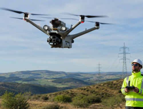
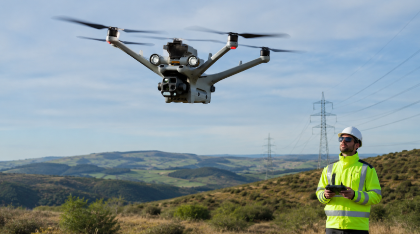
Once you’re on site, fire up your Anzu Raptor drone. It’s built for pros like you—surveyors, agronomists, infrastructure inspectors. With a 20MP 4/3-inch sensor and mechanical shutter, your images stay crisp. No blur. No rolling shutter distortion.
It gets better. With Dronelink installed on the Raptor’s smart controller, you don’t need extra gear like a second tablet or clunky cables. It’s all in your hands, literally.
Now the automation kicks in. The drone follows your flight path perfectly, right down to the altitude changes and gimbal angles.
Run vertical missions for facade inspections. Snap panos around towers. Switch to orbit mode and tweak the flight path mid-air. Want to avoid restricted zones or obstacles? You set them. The drone won’t cross your lines. And if something unexpected shows up—a crane, a crew, a flock of birds—pause, tweak the mission, and resume without losing data.
NOTE: Drone calibration, e.g. configuring thermal camera settings, are done in the Air Control App.
Capturing Reliable Drone Imagery
When carrying out your drone inspections, you want to collect the right data the first time. Time and resources are on the line.
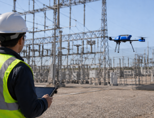
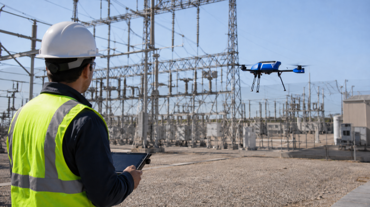
Each mission is tuned for accuracy when you use Dronelink for your Anzu unit. That way you get terrain-following for elevation shifts and can even capture images at specific intervals or overlaps.
With RTK onboard, the Anzu Raptor delivers centimeter-grade accuracy. No more setting up dozens of GCPs. You save hours. Sometimes days. And because the drone automates everything—from image capture to gimbal pitch changes—you reduce the chance of human error.
Every photo is geotagged. Every angle is repeatable. Every mission is scalable. Which is also vital when you’re you’re stitching orthomosaics or building 3D models.
Process with the Tools You Already Use
You finish flying. And your images are ready to go—clean, consistent, and georeferenced. Now what? Time to process the data.
Here’s where third-party tools come in.
Want to build 3D models? Send the data to Pix4D. Want to analyze crop health? Fire up 3DF Zephyr Free or other photogrammetry software. Want to integrate with ArcGIS? It’s all compatible. You can also use Dronelink with flight logging services like Airdata and Aloft Air Control.
Dronelink doesn’t trap you in one ecosystem. It plays nice with what you already use.
If you need to, build repeatable deliverables. You can even build automated processing workflows. And since everything is synced to the cloud, you can upload from the field and let your analyst start processing before you’re even back in the truck.
Efficiency like this adds up.
Related Reading: Certified Thermographers—A Lucrative Career in Infrared Drone Inspections
Coordinate Across Teams to Keep Every Project Synchronized and On Track
Dronelink lets you share missions, flight logs, and raw data across your team. You assign pilots. You track flights. You review errors.
Need to hand off missions to subcontractors? No problem. Need your GIS team to double-check alignment? Just give them access. And when someone needs to update a mission—say a boundary change or new inspection target—they update it once. Everyone sees it.
This kind of coordination keeps projects moving. No rework. No missing files. No crossed wires.
Keep the Budget (and Battery) in Check
Each flight requiring hands-on control from start to finish already takes time. Doing that for every manoeuvre takes even more. Training pilots to run complex missions and you’re talking loads of resources going into your operations, especially when every maneuver must be taught and memorized rather than pre-programmed.
Using Dronelink with your Anzu Raptor drone fixes that.
You plan once. You fly consistently. You train new staff in half the time.
You’ll use every second of that 45-minute flight time on the Anzu Raptor more efficiently. Plus, by automating shots, you don’t waste battery hovering around. By pre-setting gimbal angles and speeds, you reduce motor strain. Less wear and tear. Fewer repairs.
You lower costs without cutting quality.
The End Report Starts at Takeoff
Your final report is only as good as the flight that came before it. Anzu and Dronelink integration eagles you to build every step with intention, from the first waypoint to the final upload. You get field data that flows into clean, consistent, usable outputs.
Orthomosaics. Inspection photos. 3D reconstructions. Pano deliverables.
Everything aligns.
Your client asks for a reshoot? You run the same mission again. Same height. Same angle. Same path. That’s repeatability. That’s professionalism.
And when you’re managing multiple sites or working across states, it’s the only way to scale without drowning in data chaos.
A Workflow Built for Commercial Drone Operations
With Anzu and Dronelink, every decision you make—from pre-flight to reporting—is backed by powerful tech. The Raptor’s 20MP mechanical shutter captures data with zero distortion. Its RTK gives you tight, ground-truth accuracy. The drone flies for 45 minutes—that’s a full field or roof in one go.
Dronelink makes that flight smooth. Every line, every angle, every camera tilt—you command it all. And when it’s time to process, your data slips straight into the tools you already know. Pix4D. DroneDeploy. ArcGIS. This pipeline works. Mapping firms use it to fly 100+ sites a month. Utility teams use it to inspect power lines without rolling a truck. Agronomists use it to analyze plant health down to individual rows. Researchers use it to track erosion patterns and habitat change over time.
You get better deliverables. You get them faster. You stay on budget.
Download the Anzu app on Dronelink website. Note that it is not yet supported on iOS.To use it, ensure your Raptor RC is running Aloft Air Control App version 3.1.6.304 or higher.
Anzu and Dronelink Integration FAQ
- What is Dronelink and how does it benefit my operations?
Dronelink is a mission planning and flight automation software that helps you pre-plan, automate, and execute drone flights with extreme precision. You can reduce manual flying, save time in the field, and collect better data—all while minimizing pilot error.
- Which drones work with Dronelink?
Dronelink supports a wide range of drones including the Anzu Raptor Series, DJI Mavic Pro, Phantom 3 and 4, Mini 3 / Mini 3 Pro, Air 2 / Air 2S, and Inspire 1 and 2. Some models like DJI Inspire 3, Air 3, Mini 4 Pro, Mavic 3 Pro, and Parrot Anafi drones are not supported.
- What makes the Anzu Raptor different from DJI drones?
Anzu Raptor drones are made in Malaysia and don’t rely on Chinese manufacturing. They’re built for users who want the professional-grade capabilities DJI is known for, without the associated geopolitical concerns or data privacy policies, especially enterprise, public safety, and government clients.
- Can I use Dronelink on the Anzu Raptor controller directly?
Yes, you can. Dronelink has a dedicated app that installs on the Raptor’s smart controller, so you don’t need a second device to manage your flight plans. Everything happens from one screen.
- What kind of missions can I run with Anzu and Dronelink?
You can fly a wide variety of missions including grid mapping, vertical facade scans, orbit flights, panos, and custom waypoint tasks. Whether you’re inspecting buildings, surveying land, or capturing cinematic footage, it’s all programmable.
- Can I adjust my mission while flying?
Yes, Dronelink lets you make real-time changes during flight. You can adjust camera angles, update waypoints, or avoid obstacles as needed—without having to restart the whole mission.
- What image quality can I expect from the Anzu Raptor?
You get 20-megapixel images from a 4/3-inch sensor paired with a mechanical shutter. That means sharp, undistorted visuals for accurate mapping and modeling.
- Does the Anzu Raptor support RTK for high-accuracy mapping?
Yes. The Raptor includes RTK capability for centimeter-level accuracy. You can significantly reduce or even skip using ground control points, saving you hours on site.
- How long can the Raptor stay in the air per battery?
Up to 45 minutes. That extended flight time lets you cover more ground in a single trip and reduce interruptions for battery swaps.
- Is mission planning cloud-based or local?
You get both. You can plan missions on your desktop, save them in the cloud, and access them on your controller in the field. This also makes collaboration with team members smooth and remote-friendly.
- Can I use Dronelink with other tools like ArcGIS or Pix4D?
Absolutely. Your image data is fully compatible with common third-party tools used for post-processing, modeling, and GIS. No conversion hassles—just import and get to work.
- What’s the benefit of using Dronelink for a team operation?
It helps you share missions, sync flight logs, and coordinate across multiple pilots or departments. Everyone works from the same mission files, cutting down on confusion and boosting repeatability.
- Does Dronelink help reduce operational costs?
Yes, significantly. By automating flights, reducing manual errors, and improving data capture, you cut down labor time and equipment wear. That translates into real cost savings over time.
- How does Anzu address data security concerns?
Anzu partners with Aloft, a certified ISO 27001 and SOC 2 Type II provider. This means your flight data is protected with top-tier cybersecurity standards and is not routed through Chinese infrastructure.
- Is there a licensing agreement between Anzu and DJI?
Yes. Anzu Robotics licenses drone technology from DJI but manufactures its products independently in Malaysia. This setup gives you DJI-level hardware performance with added regulatory peace of mind.
