

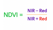
Multispectral cameras on drones snap pictures in several narrow spectral bands (green, red, red-edge, near-infrared, etc.). Each band reveals unique information. For example, healthy plants soak up red light but strongly reflect near-infrared (NIR). By comparing these bands (say, computing NDVI – Normalized Difference Vegetation Index), you can map plant health in detail, and up up with data-rich maps.

Multispectral imaging originally came from satellites and military tech, but now drones have brought it right into farmers’ hands. You can fly your drone on demand, capturing data when needed (sunny, calm days). Drones can spot trouble in fields up to tens of hectares per flight – something satellites can’t match in resolution or flexibility.
How Multispectral Drone Systems Work
A multispectral drone has a GPS, flight controller, and – most importantly – a multispectral camera payload. The camera might have multiple sensors, each with its own filter. For example, the DJI Mavic 3 Multispectral has five cameras: one 20MP 4/3″ RGB camera and four 5MP cameras for Green, Red, Red-Edge, and NIR. These snap photos simultaneously. Other drones like DJI Phantom 4 Multispectral use a single gimbal-mounted array of six cameras (RGB + 5-band).
Side by side images with DJI P4:

Flight and data capture
On a mission, you set your drone’s path (with plenty of overlap between images). GPS and often RTK/PPK systems stamp each image with location/altitude, so you can stitch the photos into geo-referenced maps. A built-in sunlight sensor (as on many DJI models) records solar irradiance for radiometric calibration – this keeps your NDVI maps consistent under changing sunlight. Most agricultural drones with multispectral sensors also use mechanical shutters (unlike cellphone cameras). That means each shot is distortion-free, which is crucial when mapping while flying fast.
Data processing
After the flight, specialized software (like Pix4Dfields, Agisoft, or DJI Terra) aligns the multispectral images into an orthomosaic. Then it computes vegetation indices. The most famous is NDVI (Normalized Difference Vegetation Index). NDVI is computed as below, and yields values from -1 to 1.
High values (~0.8-1.0) indicate dense, healthy crops; zero or negative values mean barren soil or water. NDVI maps color-code the field: bright green is good, brownish indicates trouble.
Aside from NDVI, drones use other indices. NDRE (Normalized Difference Red Edge) uses the red-edge band instead of red; it’s better for late-season, high-density crops. GNDVI replaces Red with Green for some subtleties. OSAVI adjusts for soil background. Each index pulls out different clues. For instance, the coastal blue band (around 450nm) can highlight aquatic plants or algae in water. In practice, most multispectral drone users compute several indices to get a fuller picture.
Tech Tip: Some advanced sensors (like MicaSense Altum-PT or Sentera 6X) even capture thermal or extra bands. These fusion products (multispectral + thermal, or 10 bands) let you analyze water stress or disease more deeply. You can even spot fungi by temperature differences and then confirm by an NIR drop – that’s next-level precision.
Key Vegetation Indices (NDVI and Friends)
A big part of multispectral imaging is turning raw light data into simple metrics. These indices are formulas combining two or more bands. The workhorse is NDVI. It’s so popular because it correlates strongly with plant biomass and chlorophyll. In healthy green areas, NDVI approaches +1; bare soil gives values near 0; deep water or clouds yield negative values. Researchers love NDVI for insight into plant chlorophyll content, and it is relatively stable under different lighting and soil conditions.
Another index is NDRE (Normalized Difference Red Edge). It swaps out Red for the Red-Edge band (~720–750 nm). NDRE is sensitive in mid-to-late season when NDVI can saturate. For example, a wheat field at peak greenness might max out NDVI, but NDRE will still show gradients of vigor.
Here are the results of a survey of a pumpkin patch in the Pacific Northwest was conducted using the RedEdge-P sensor by MicaSense, mounted on a DJI M300:
Pumpkins in Field
 |
 |
|---|---|
| NDVI | NDRE |

Other common ones include GNDVI (using green and NIR), VARI (an RGB index that tries to mimic NDVI from just visible bandsgim-international.com), and NDWI (using Green and NIR to estimate water content). Some systems even output an easy “Stress Index” or “Vigor Map” using proprietary formulas.
To interpret them, imagine looking at a heatmap of your field. Bright yellow or green zones means high NDVI – lush canopy. Duller red/orange patches flag trouble. Instead of walking the whole farm, you focus on those hotspots. For example, a farmer might see an isolated low-NDVI patch (brown area) and discover a clogged irrigation line or early blight, then fix it before yield is lost. This is precision agriculture in action, all because your drone decoded the invisible spectra.
Multispectral Drones in Agriculture
Today’s agricultural drones use multispectral data as a core tool for precision farming. You fly, you map, you act:
- Early Stress Detection: By capturing NIR and red-edge, drones can spot stressed plants long before you see yellow leaves. Drought stress, nutrient deficiencies, or disease show up as subtle dips in reflectance. Early detection means you solve problems early, preventing losses.
- Variable-Rate Treatments: The maps let you apply fertilizer or water only where it’s needed. For instance, if one quarter of your field has healthy NDVI and another quarter is low, you direct irrigation and fertilizers to the needy zone. This saves costs: less waste, higher yields.
- Yield Prediction: Researchers have found that summing up NDVI over a season correlates with yield. In simple terms, greener fields tend to produce more. Some farms calibrate historical NDVI maps with harvest data to predict output. This helps with forecasting and resource planning.
- Field Management: Generate precise prescription maps for spraying/puckers. Use orthomosaics for plant counting or gap detection in vineyards or orchards. Track crop growth stage uniformly over large areas (e.g., cereals, sugarcane).
Satellite NDVI data can miss small issues due to coarse resolution. Drones, flying just a few hundred feet high, can get centimeter-level detail. That high resolution is an asset for farmers – you can actually see individual plants or small patches. This capability is why agricultural drones are becoming a standard tool on farms of all sizes.
The payoff is huge. Farmers who use drone multispectral data often see significant ROI. They use less pesticide and fertilizer per acre while boosting yields. For instance, growers can rely on data from NDVI maps to cut fertilizer on sections of the field where crops are already lush)and reapply it on areas where NDVI is low. The result is healthier plants all around and lower input costs. In very broad terms, analysts project the global ag-drones market to jump from about $5 billion in 2023 to nearly $24 billion by 2032. A big part of that growth is multispectral imaging, because farmers everywhere are hungry for data they can trust.
Beyond the Farm: Other Multispectral Uses
While agriculture is the main area for multispectral drones, the technology is also beneficial in other fields:
- Forestry: Drones scan forests to map tree species, health, and density. Healthy canopy and stressed trees reflect NIR differently, so you can spot disease, pest infestations (like bark beetles), or illegal logging early. Estimating biomass or timber volume is also possible by correlating NDVI/NDRE with tree mass. For example, environmental groups use red-edge sensors to monitor forest recovery after fires.
- Environmental Monitoring: Wetlands and water bodies often use the coastal blue and NIR bands. Coastal blue highlights algae and submerged plants in shallow water. NIR can detect differences in vegetation types or map polluting runoff (sediment reflects NIR). In land management, multispectral drones map invasive species, track drought effects, and monitor reforestation projects.
- Precision Landscaping / Urban Planning: City planners use multispectral flights to assess urban green space. A tree canopy map from NDVI can justify planting more trees. It can also spot which trees are under stress or dying in a city block.
- Infrastructure & Safety: Some utility companies fly multispectral drones to inspect power line corridors and pipelines. NDVI can reveal encroaching vegetation (a fire risk), or differentiate healthy grass from diseased or dead patches around installation sites.
- Research & Archaeology: Multispectral imaging helps archaeologists discover buried walls or foundations. Different ground materials (stone, dirt) have different moisture and reflectance. Infrared bands can reveal old structures invisible to plain sight.
- Algae & Mineral Detection: By selecting custom bands, drones can map chlorophyll-a in water (algae blooms) or even certain minerals on bare ground.
Why Drone-Based Multispectral Wins (and Its Challenges)
Why drones beat other methods:
- Higher Resolution: Commercial satellites might see at best 1–3 m per pixel for NDVI. Even balloons or airplanes can be costly. Drones fly low and get a few centimeters per pixel. This detail lets you pinpoint issues field-wide, plant by plant if needed.
- On-Demand Data: Satellites have fixed orbits; your area might have clouds or re-visit in weeks. A drone can fly weekly or after every big storm. You control the schedule.
- Flexibility: Drones can be deployed on one field today, another next week, anywhere there’s line-of-sight. Ideal for medium and small farms that satellites or big aircraft can’t economically service.
- Integrated Systems: Modern drones sync GNSS/RTK with camera triggers (like DJI TimeSync). This means each pixel is accurately geo-tagged, enabling precise mapping.
What to watch out for:
- Sun and Shadows: Multispectral sensing needs good lighting. You get best results on sunny, cloud-free days (though some indices can still work with overcast). The drone’s solar irradiance sensor helps normalize different light conditions, but very dark clouds or sunrise/sunset can complicate interpretation.
- Calibration: Sensors must be calibrated. Good systems include reflectance panels or auto-calibration (the DJI drones like the Mavic 3M have a “Sunlight Sensor” to compensate). Without this, NDVI values from one flight to another can’t be directly compared.
- Data Processing: Turning raw images into maps takes software and know-how. You need stitching (orthomosaics), index calculation, and interpretation. Luckily, platforms like DroneDeploy, Pix4D, or even open-source GIS tools handle this, but there’s a learning curve.
- Cost: The latest multispectral drones (detailed below) can cost anywhere from a few thousand to tens of thousands of dollars. However, when you calculate the savings in fertilizer or increased yield, the investment often pays off quickly for commercial farms.
Despite these challenges, the benefits are undeniable. Drones with multispectral cameras give you super-sight at the right time and scale. You can identify tiny issues before they blow up into big problems.
Upskill Today: Drone Multispectral Imaging Course available at ABJ Academy
Best Multispectral Drones of 2025
The market is full of drones purpose-built for multispectral imaging. Here are some top options, along with their specs and standout features (prices are ballpark and may vary by region):
- DJI Mavic 3 Multispectral
A foldable, portable workhorse. This is DJI’s lightweight flagship for farming. It packs a 20MP 4/3″ RGB camera plus four 5MP multispectral cams (Green, Red, Red Edge, NIR). It flies ~43 minutes per charge and covers up to ~150–200 hectares per mission. Critically, it has RTK positioning for centimeter accuracy, and a mechanical shutter for crisp images. Users love that it’s as easy to launch as a Mavic 3, but with a “sunlight sensor” that boosts NDVI accuracy. Price: around $8,000–9,000 (with fly-more kit). For many farms, the Mavic 3M is a sweet spot of affordability and power.
- DJI Matrice 350 RTK + Sentera 6X Thermal Pro
A heavy-duty powerhouse. The Matrice 350 RTK is DJI’s industrial quadcopter (IP55-rated) that can carry multiple payloads. Pair it with the Sentera 6X sensor, and you get five 3.2MP multispectral bands + a 20MP RGB + thermal data all synchronized. Flight time is ~50–55 min (shorter with heavy sensors). It’s built for big jobs – monitoring large farms, forests, or industrial sites. The 6X’s thermal camera adds a new layer: you can see plants’ heat stress in real time and confirm it with NDVI. This combo is pricey (M350 RTK base ~ $10,000, Sentera 6X ~ $12,000), but for large agricultural operations or research teams needing top-tier data, it’s worth the value.
- Quantum Systems Trinity Pro + MicaSense Altum-PT
A VTOL fixed-wing drone with serious endurance. The Trinity Pro is a German-made eVTOL (takes off vertically, then flies like a plane) that can stay aloft for ~90 minutes. It covers huge swaths (hundreds of hectares) and has swappable cameras – RGB, thermal, or multispectral. One popular setup is attaching the MicaSense Altum-PT sensor: it combines a high-res RGB camera, a 3.2MP thermal sensor, and 5×3.2MP multispectral bands. In other words, you get NDVI and thermal layers in one flight. Quantum’s Trinity Pro retails for about $21,000 (drone only), and the Altum-PT is another ~$14,000. For large-scale farms, forestry agencies or research institutions, this is a portfolio of sensors in one package. It’s also tough – designed for field longevity. The Altum-PT delivers twice the spatial resolution of the original Altum, aplus a faster capture rate and RTK support
- senseFly eBee Ag (eBee X) + MicaSense RedEdge-MX
A fixed-wing mapping drone by Swiss company senseFly (now part of Parrot). The eBee Ag (or the newer eBee X with agriculture kit) is built for large fields. It’s not cheap (airframe + kit ~$20K+), but it yields 90-minute flights and can cover 150+ hectares per flight. Its bundled camera is the MicaSense RedEdge-MX: a 5-band multispectral (Blue, Green, Red, Red Edge, NIR) at 1.2 MP per band. That yields very accurate NDVI maps. eBee Ag has RTK/PPK built in, so geo-mapping is pinpoint. Many agri-consultants use it to scout large farms or vineyards. Its specialty is sheer coverage – one flight can do what a quadcopter might in 10 flights.
- DJI Phantom 4 Multispectral
The classic field mapper (from 2018) that paved the way. While a bit older, the P4M is still popular in drone services. It has a 6-camera array: one RGB and five 2MP band cameras (Blue, Green, Red, Red Edge, NIR) on a stabilized gimbal. Flight time is ~27 minutes. This rig was the first all-in-one for NDVI that consumers could buy. It even has an integrated sunlight sensor and Live NDVI view capability. You can still find one new for around $6,000 (including controllers and RTK unit). It’s a workhorse for small farms or educational use – proven and reliable.
- Other Notables: Sensor-Only Packages – If you already have a drone (M300/M350, Wingtra, etc.), you can add a MicaSense RedEdge-MX (~$4,750) or Parrot Sequoia ($3,500) payload for multispectral capability.
Each of these platforms has its niche. The Mavic 3M is incredibly user-friendly and portable (folds up in a backpack) – great for small farms or quick surveys. The Matrice/Trinity systems cost more but deliver enterprise-grade accuracy and endurance. The eBee is ideal for huge fields and surveying.
Organizations like DroneDeploy and Pix4Dfields provide the mapping software to turn that drone data into actual farm decisions.
Multispectral Imaging Drone FAQ
What is multispectral imaging in drones?
Multispectral imaging in drones means capturing images using multiple specific light bands beyond visible colors. This includes wavelengths like near-infrared (NIR), red-edge, and green, which help assess crop health, water stress, or vegetation density with more precision than standard RGB cameras.
How does multispectral imaging work?
It works by using sensors that collect data in specific spectral bands to reveal details invisible to the naked eye. Each band interacts differently with plant materials—healthy vegetation reflects more NIR and less red—so when processed, this data creates vegetation maps like NDVI or NDRE.
What is NDVI and why is it important?
NDVI (Normalized Difference Vegetation Index) is a key vegetation index that shows plant health. It compares NIR and red reflectance using the formula (NIR – Red)/(NIR + Red), producing a value between -1 and 1. Higher values signal healthy vegetation, while lower values flag potential stress or bare ground.
What can drones with multispectral cameras be used for?
Drones with multispectral cameras are mainly used for precision agriculture, forestry, and environmental monitoring. In farming, they detect early crop stress, guide fertilizer use, and predict yields. They also help monitor forests, wetlands, invasive species, or even archaeological sites.
Why is multispectral imaging better than RGB imagery?
Multispectral imaging provides deeper insights by analyzing reflected light beyond visible wavelengths. RGB imagery can only capture surface-level changes, while multispectral data shows early signs of crop stress, disease, or nutrient deficiency before visible symptoms appear.
Which spectral bands are most commonly used in agriculture?
The most common bands are Green, Red, Red Edge, and Near-Infrared (NIR). These bands provide the best insight into photosynthetic activity, chlorophyll content, and vegetation stress levels—critical for managing crops efficiently.
What are the best multispectral drones in 2025?
Top multispectral drones in 2025 include the DJI Mavic 3 Multispectral, Matrice 350 RTK with Sentera 6X, and Trinity Pro with MicaSense Altum-PT. These models offer powerful sensors, high endurance, RTK support, and advanced mapping tools for farm-scale and research-grade imaging.
How much does a multispectral drone cost?
Multispectral drones range from around $6,000 to over $30,000 depending on features and payloads. Entry models like the DJI Phantom 4 Multispectral cost less, while advanced systems with thermal and high-resolution sensors can cost significantly more.
Can I fly a multispectral drone without a license in the U.S.?
No, you need a Part 107 Remote Pilot Certificate from the FAA to fly drones commercially in the U.S. This includes using drones for agricultural mapping, surveying, or any other business-related purpose, including with multispectral cameras.
How accurate are multispectral imaging drones?
Multispectral drones can achieve centimeter-level accuracy when equipped with RTK or PPK positioning. Their radiometric and geo-tagging capabilities enable highly accurate vegetation maps when flown properly under good lighting.
How large of an area can a drone cover per flight?
Drones like the DJI Mavic 3M can cover up to 200 hectares per flight, while fixed-wing drones can cover 300+ hectares. The exact area depends on battery life, altitude, flight speed, and camera resolution.
What kind of software is used to process multispectral data?
Popular software for processing multispectral data includes Pix4Dfields, DJI Terra, Agisoft Metashape, and DroneDeploy. These tools generate orthomosaics, NDVI maps, and prescription maps from raw flight data.
Is sunlight a factor in multispectral imaging?
Yes, sunlight significantly affects multispectral data quality. Most drones include a sunlight sensor or irradiance panel to calibrate readings, but it’s best to fly under clear skies between 10 a.m. and 2 p.m. for consistent lighting.
Can multispectral drones work in cloudy conditions?
Yes, but results may be less accurate unless calibrated with irradiance sensors. Overcast skies reduce NIR reflectance, which can distort vegetation indices if not properly corrected during data processing.
What is red-edge, and why is it useful?
Red-edge is a spectral band between visible red and NIR that is sensitive to early plant stress. It helps detect changes before NDVI does, especially during peak growing stages when NDVI may become saturated.
Can I retrofit my current drone with a multispectral sensor?
Yes, many drone platforms support aftermarket multispectral sensors like MicaSense RedEdge or Sentera 6X. Just make sure your drone can carry the payload and supports GPS geo-tagging and camera integration.
How do multispectral drones support variable rate application?
They help by creating prescription maps that guide machinery to apply inputs like fertilizer or water only where needed. These maps are generated from NDVI or other indices, improving input efficiency and reducing costs.
What’s the difference between multispectral and hyperspectral imaging?
Multispectral imaging uses fewer bands (usually 4–10), while hyperspectral imaging captures hundreds of narrow bands. Multispectral is better for practical use in agriculture due to faster processing and simpler data requirements.
Can multispectral imaging help predict crop yields?
Yes, there is strong correlation between vegetation indices (like NDVI) and crop yield. Many farms and researchers use historical NDVI data to estimate yield potential and plan harvesting or sales.
Is multispectral imaging useful for small farms?
Yes, even small farms benefit from detecting early stress and reducing wasteful input use. Drones like the Mavic 3M offer affordable, high-quality multispectral data that’s actionable at any scale.

