

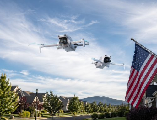
Cell tower inspections are the backbone of our connected world. Without them, your phone calls, texts, and endless TikTok scrolling could come to a grinding halt. These towering structures keep us linked, but they need regular check-ups and maintenance to stay in top shape. But inspecting them is risky, time-consuming, and—let’s be honest—not for the faint of heart.
Traditionally, cell tower inspections involved brave climbers scaling hundreds of feet in the air. While impressive, it’s also dangerous and slow. The stakes are high.
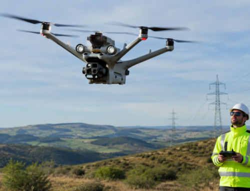
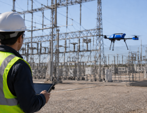
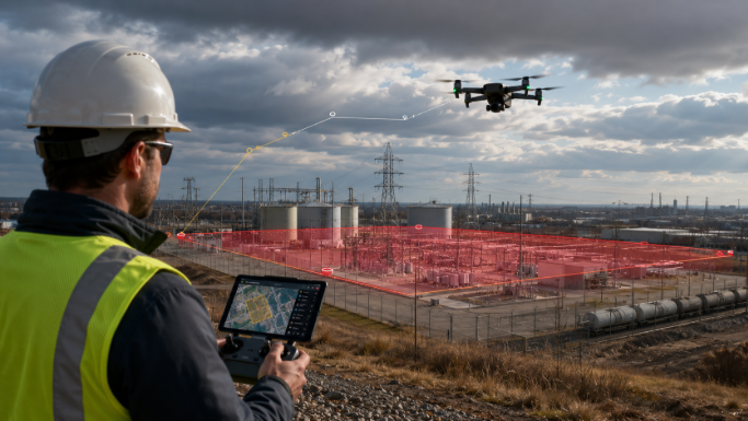
Now, drones make inspecting cell towers faster, safer, and way more efficient. With high-tech cameras and sensors, drones can be remotely piloted around a tower, capturing every detail in minutes. No climbing. No dangling. No risk of falling. And this data instantly shared with collarobrators through cloud based systems. The drones can cut cell tower inspection costs by up to 50% and up to five times faster than traditional methods.
Benefits of Using Drones for Cell Tower Inspections
Drones are rewriting the rulebook for cell tower inspections. The benefits are too good to ignore, and once you see them, you’ll wonder why anyone would inspect a tower the old way.
Safety Factor
Climbing a cell tower is one of the riskiest jobs around. Every year, accidents happen, and the stakes are literally life and death.
In fact, cell tower technicians were 10 times more likely to die on the job than other construction workers, and Department of Labor’s Bureau of Labor Statistics even once labelled it the most dangerous job in the country – reporting more fatalities than logging workers and those in the structural iron and steel industry..
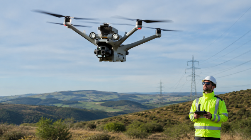
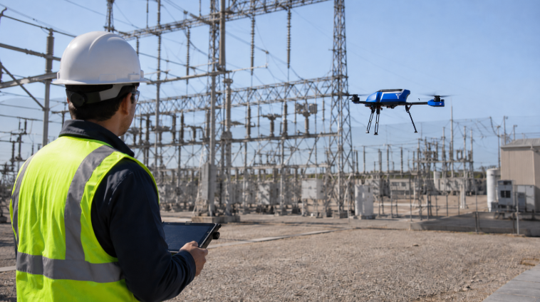
Today, drones eliminate the need for human climbers.
No more harnessing up. No more scaling hundreds of feet. Drones keep inspectors safely on the ground while they capture every angle.
Fast, Efficient, and Always On the Clock
Time is money, and drones save you both. A traditional cell tower inspection can take hours—or even days. But drones can collect data in as little as 20 minutes. Features like rapid deployment add to the efficiency of the operation.
They transmit data in real-time for analysis by engineers and relevant stakeholders in the system. This means you can spot issues instantly and get ahead of potential problems before they escalate.
Cost Value
Drone cell tower inspection cost is a fraction of traditional methods. Fewer workers. Less downtime. No expensive safety gear.
Working with the UAVs instead of rope-access methods for different kinds of inspections can cut costs by as much as 70% while minimizing downtime-related revenue losses by up to 90%.
There are also reduced liability insurance costs. The risks of traditional tower inspections – operating at dangerous heights, adverse weather, and equipment malfunctions – drive up liability insurance premiums for companies, as accidents can lead to costly claims and legal repercussions.
With drones, organizations decrease the likelihood of accidents but also reassures insurers, resulting in lower premiums. That way companies can allocate resources more effectively, improving operational efficiency while ensuring safer and more reliable inspection practices.
That’s the kind of efficiency your team—and your budget—will love.
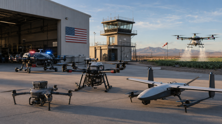
Essential Equipment for Drone-Based Cell Tower Inspections
Not all drones are created equal. When it comes to inspecting cell towers, you need the right equipment. Without it, you’re risking bad data, wasted time, and frustrated clients.
Picking A Drone And Imaging System
Look for three key features: stability, battery life, and camera quality. Stability ensures smooth flights, even in windy or turbulent conditions often encountered at tower sites. Long battery life keeps you airborne longer—critical when you’re dealing with multiple towers. And a high-quality camera is non-negotiable.
Drones such as the DJI Matrice 350 RTK excel in this regard with its advanced obstacle avoidance system and IP55 rating for durability, allowing it to maintain performance in challenging weather. Equipped with RTK positioning for centimeter-level accuracy, it’s a top choice for professional inspections.
Battery life is another vital consideration, as it determines how long the drone can remain airborne to complete extensive inspections. Models like the SwitchBlade-Elite stand out with a flight time of up to 50 minutes, reducing the need for frequent battery changes and enabling uninterrupted assessments of multiple towers. Its hot-swappable batteries allow for continuous operation, a critical feature when working on large-scale projects.
Similarly, the Inspired Flight IF800 Quadcopter offers a 54-minute flight time and dual hot-swappable batteries, ensuring you have ample power to cover extensive areas without delays. The Autel EVO Max 4T, with a 42-minute flight time and advanced AI-driven autonomy, is another excellent option, providing seamless operations even in GPS-denied environments.
Camera quality is non-negotiable for accurate and detailed inspections. High-resolution cameras like the Zenmuse H30 series supported by the DJI Matrice 350 provide exceptional imaging capabilities, including thermal and zoom functionalities. This system includes a 40 MP high-resolution zoom camera and a thermal camera with a 1280×1024 resolution, ideal for detecting anomalies in tower structures.
Similarly, the Skydio X10 features a FLIR Boson+ thermal camera with <30 mK sensitivity, enabling precise heat signature detection, along with AI-driven autonomous navigation for enhanced efficiency. Another noteworthy model is the Yuneec Typhoon H520E-RTK, which boasts a dual-camera system capable of simultaneous thermal and RGB imaging, making it a reliable choice for diverse inspection needs.
For those seeking an imaging system integreed into the drone, you have the likes of the Autel EVO II Dual 640T V3 offers a 50 MP visual camera combined with a 640×512 thermal imaging sensor, providing comprehensive coverage in both visible and thermal spectrums.
For portability and quick deployment, the Parrot ANAFI USA offers a lightweight, foldable design, coupled with dual 21 MP visual cameras and a FLIR Boson thermal camera. Its near-silent operation and robust data encryption make it ideal for sensitive or covert missions. The Teledyne FLIR SIRAS is another strong contender, featuring a dual-camera system with FLIR’s MSX technology for enhanced thermal and visible image clarity, along with an IP54 durability rating for harsh environments.
Related Reading: Top 14 Thermal Drones Based On Imaging Systems & Flight Performance
Software: Smarter Flights, Better Data
Every second counts, especially when dealing with complex towers at high altitudes. Flight planning tools like DroneDeploy help you map out precise routes. No wasted battery. No missed angles.
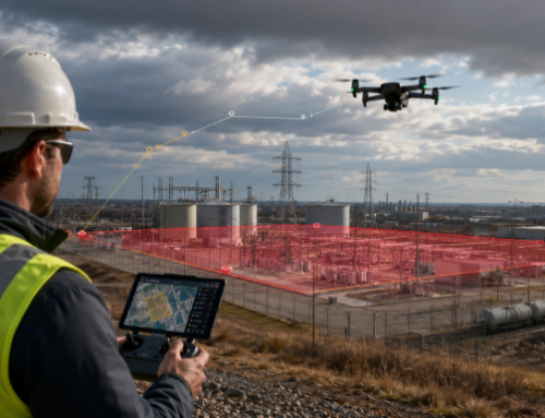
With the Esri and DroneDeploy integration, you won’t spend hours sifting through outdated maps and scattered data. You can now view real-time, high-resolution drone maps directly in your ArcGIS instance. That way you can have all exact location, condition, and compliance status of every tower, all in one place. Plus, you save big by eliminating the need for costly third-party development or satellite imagery subscriptions.
Data on wear and tear to potential hazards of the cell towes becomes instantly available for your entire team. Imagine spotting corrosion or misaligned antennas without even stepping foot on-site. By documenting inspections visually and storing them in ArcGIS, you create a seamless record for regulators, maintenance teams, and stakeholders.
Modules like Pix4DScan and Pix4DInspect are built for tower inspections, handling everything from flight management to detailed modeling. You can stitch images, process 3D models, and analyze structures with pinpoint accuracy.
For airspace management, you there are solutions like Skyward, which handle airspace checks, authorizations, and risk assessments—essential when flying near regulated zones. Fleet management on the otherh and can be carried out with systems such as the Airdata UAV platform.
How to Prepare for a Drone Cell Tower Inspection
Without the right procedures, you risk wasted time, bad data, or worse—violating laws.
– Regulatory Compliance
Flying a drone isn’t a free-for-all. You need to get familiar with local aviation regulations. Countries like the U.S. require FAA Part 107 certification for commercial drone operators. Other regions might need specific permits or airspace authorizations.
Related Reading: Key FAA Drone Regulations Every U.S. Pilot Should Know
– Site Assessment
A good inspection starts on the ground.
Scope out the area before launching. Check for obstacles like power lines, trees, or nearby structures. Hazards can ruin your flight—or your drone.
Next, plan your flight path with the integrated software. You’ll get precise routes that maximize coverage and conserve battery. Speaking of batteries, bring extras, or a portable charging unit.
– Pre-Flight Checklist
Inspect your equipment. Are propellers intact? Is the camera secure? Is your drone updated with the latest firmware?
Finally, assess the weather. Strong winds, rain, or low visibility can wreck your flight. A clear, calm day is your best bet for flawless results.
With proper prep, you’ll avoid costly mistakes and deliver top-notch results every time. Trust us, the extra effort is worth it.
Conducting the Drone Cell Tower Inspection
The goals here are precision, safety, and capturing actionable data.
Flight Execution
Start by implementing your planned flight paths. Follow the path you mapped out during site assessment—this ensures no blind spots and optimal efficiency.
Always maintain a clear line-of-sight with your drone. This is is a regulatory requirement in most regions, and you will need a special waiver for Beyond VIsual Line of Sight (BVLoS) operations.
Safety first, always. Keep a close eye on your surroundings, and never ignore weather changes. Sudden gusts or rain can derail even the best flight plans.
Data Capture Techniques
This comes down to the imaging system of your drone. It can be an integrated camera, or a payload that is attached to the drone, depending on the choice you went with. HIgher resolutions are always better, to get the clarity needed to inspect bolts, wires, and panels.
Use wide shots for an overall view of the tower. Then, zoom in for close-ups of key components like antennas and structural joints. These close-ups are where issues often hide.
Angle matters too. Fly at a 45-degree angle for most shots; it minimizes distortion and provides the most detail. Remember, shaky footage is useless. Stability is your best friend.
Real-Time Monitoring
With real-time data streaming, you can catch problems on the spot. Many drones allow live feeds to your tablet or control station. Use it.
If you see something critical—like a damaged antenna—you can adjust your flight plan immediately. This saves time and ensures you don’t miss anything important.
Clients love this level of responsiveness. Plus, it gives you the chance to flag urgent repairs before they escalate into costly failures.

Challenges To Watch Out For During Drone Cell Tower Inspection
Tower inspections are no walk in the park. High altitudes, electromagnetic interference, and unpredictable winds create a risky environment.
Electromagnetic Interference
Ectromagnetic signals can disrupt your drone’s transmission, causing you to lose control or video feed. Most modern drones have some protection, but don’t rely on it completely. Maintain a safe distance—100 feet is a good start, but you can approach as close as 50 feet with caution.
Learn about how Energy/Radio Frequencies impact your drone: ABJ Drone Cell Tower Inspection Course
Poor Visibility
Flying up to 1,000 feet means visibility can get tricky. Fog, haze, and even the tower itself can obscure your view. Check weather reports and aim for clear conditions.
Plan your inspection one section at a time or move along with the drone to keep it in sight. Better yet, have a visual observer on your team. Their job is to keep eyes on the drone and the surroundings.
Guy Lines
Guy lines stabilize towers, but your drone’s sensors might miss them. These lines are notorious for snagging drones and causing catastrophic crashes. To stay safe, identify the guy line anchor points on the ground. Avoid horizontal flights near these lines; instead, stick to vertical movements from known anchor spots. Use your drone’s Obstacle Avoidance feature if available.
Strong Winds: Know When to Stop
Wind conditions at cell tower heights can turn on a dime. Use GPS Hold and Altitude Hold features to maintain stability, but always monitor your drone. If it starts to struggle against the wind, don’t push it. Land and wait for better weather.
Airspace Restrictions
While you can exceed the 400-foot limit when near a structure, you’re not off the hook for airspace rules. Controlled airspace still requires authorization. Follow the regulations, avoid conflicts with other aircraft, and stay compliant.
Post-Inspection Processes: Data Processing & Reporting
To turn the data into actionable insights, you need a way to process it. That’s where 3D modeling and analysis software comes in. They stitch together images and videos into detailed 3D models of the cell tower. You can zoom in on problem areas, measure dimensions, and visualize the structure from angles impossible to capture with traditional methods.
Plus, automated tools can detect anomalies—like damaged cables or loose bolts—faster than any human eye. These insights mean quicker decisions and fewer surprises later on.
We’ve already mentioned some examples of software for your drone inspection task. Here is things you should look into when making your choice:
- Data Management and Integration: The software should seamlessly ingest and manage various data types, including images, videos, 2D orthomosaic maps, and 3D digital twin models. An intuitive, searchable database that correlates data from multiple sources is essential for streamlined analysis and AI implementation.
- Advanced Visualization Tools: Look for platforms offering immersive 3D visualizations, allowing precise measurements and detailed analyses of assets. Features like point cloud models and mesh reality models enable accurate assessments of tower structures and equipment.
- AI-Powered Analytics: Integrated AI capabilities can automate issue identification, classification, and prioritization, enhancing inspection efficiency. The ability to develop, test, and deploy computer vision AI within the platform is advantageous for automating inspection processes.
- Workflow Automation: Effective software should support end-to-end workflow management, from data capture to analysis and reporting. Features like customizable dashboards, automated document routing, and integration with existing ticketing and dispatch systems can streamline operations.
- Collaboration and Sharing: Ensure the platform allows secure sharing of data and visualizations with stakeholders, both internal and external. Built-in data viewers for various document types and control over access levels facilitate effective collaboration.
- Compliance with Industry Standards: The software should facilitate adherence to relevant standards, such as the TIA-222 for telecom towers, ensuring inspections meet regulatory requirements. Features that assist in structural analysis and comparison of as-built structures to engineering drawings are beneficial.
- Scalability and Flexibility: Opt for a solution that can scale with your operations and adapt to various inspection scenarios. A flexible, cloud-based platform that supports integration with other enterprise systems can accommodate growing and evolving needs.
Your report should highlight findings with visuals. Include high-resolution images of damaged areas and annotated 3D models where possible. Break down your findings into sections: what’s fine, what needs maintenance, and what’s urgent. Be specific. For example, note a “corroded anchor bolt at 50-foot elevation on the south side.”
End with clear recommendations. Suggest repair timelines or additional inspections if necessary.

What’s the Cost of a Drone Cell Tower Inspection?
Several factors influence drone cell tower inspection costs. First, there’s the complexity of the tower. A simple monopole tower will be cheaper to inspect than a multi-faceted lattice structure or one with multiple antennas.
Next, location matters. Remote sites often involve travel expenses, while urban areas may require additional permissions, adding to the cost. Then there’s the drone equipment and software—higher-end tools like thermal cameras or AI-powered analysis bump up the price but deliver unmatched precision.
On average, prices range from $150 to $400 per tower. Some inspections, especially those requiring advanced sensors, can go as high as $1,500.
Setting Service Rates: How Much Should You Charge?
Determining how much to charge for cell tower inspection starts with knowing your value. Factor in your costs—gear, travel, time, and expertise. Then research your competition. Are other professionals in your area charging $200 per tower? Consider pricing within that range, or higher if you offer premium services.
Offering tiered pricing is a smart move. For example, a basic visual inspection might start at $150, while a full thermal and 3D analysis package could go for $500. Competitive pricing strategies like this let clients pick a service level that matches their needs and budget.
The key is balance. You want rates that reflect your expertise without pricing yourself out of the market. Nail this, and you’ll attract more clients while maximizing profits.
Opportunities in the Drone Inspection Industry
Cell towers are everywhere, and they’re constantly expanding. With over 142,000 towers in the U.S. alone, companies need efficient ways to inspect them.
This demand translates into plentyjob opportunities. Companies are actively hiring for cell tower drone inspection jobs. From telecom giants to independent contractors, everyone is looking for skilled operators. And it’s not just in the U.S.—this is a global trend.
In 2022, the drone inspection and monitoring market hit a $11.9 billion. By 2032, this industry is projected to get to an impressive $42.19 billion. That’s nearly quadruple growth in just a decade. And you can be part of it.
How to Become a Drone Cell Tower Inspector
First up, you’ll need a commercial drone license—like the FAA’s Part 107 certification in the U.S. Without it, you can’t legally fly drones for business.
Pass FAA’s Aeronautical Knowledge Test to get the certification. Before taking the test, get well versed on aviation law, especially Part 107 of Title 14 of the Code of Federal Regulations. This part specifically covers commercial drone operations. You’ll also want to master drone piloting basics—from GIS data interpretation to understanding weather patterns and flight safety.
Cnline study guides or courses are available for you to prepare for the test.
Take ABJ Part 107 Preparatory Course
Once you pass, submit your application via the FAA’s IACRA portal. You’ll also need to pass a TSA background check. When all that’s done, congratulations! You’re officially a Remote Pilot Certificate holder. This certification is valid for two years, so you’ll need to renew it periodically.
Next, build expertise in using drone inspection tools, including flight planning and data analysis software. Specialized certifications in imaging systems and processes can also set you apart.
Drone Thermography Level 2 Certification and 3D Modelling Course from ABJ now available.
The potential for growth is huge. Whether you work for established cell tower inspection companies or start your own gig, the possibilities are endless. With experience, you could command salaries upwards of $80,000 a year or scale your business to handle multiple clients.
Also Read: Drone Pilot Training: Certifications, Benefits And How Much Money You Can Make