
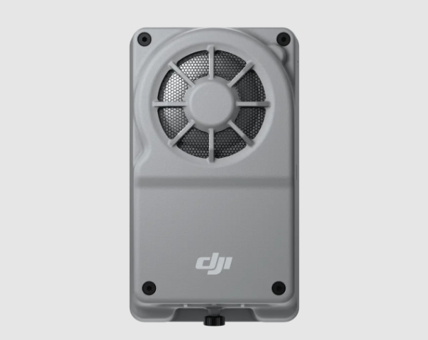
A tiny onboard computer called the Manifold 3 sits at the heart of the Matrice 400 and other new aircraft. With this device, your drone can think, react, and act on its own—miles away from you.
A Compact Brain for the Sky
It’s a computer as powerful as a high‑end laptop stuffed into a box that weighs roughly 120 grams. Measuring just 98 × 57 × 36 millimetres, it delivers up to 100 TOPS (trillion operations per second) of AI computing power thanks to an NVIDIA Jetson Orin NX chipset. This little box uses GPU and DLA (Deep Learning Accelerator) cores to run complex neural networks and machine‑learning models on the edge without sending data to the cloud. It holds 16 GB of LPDDR5 memory, a 256 GB SSD for storage, and draws about 33 watts of power. Despite such muscle, it slips under the drone’s frame with minimal impact on flight time, giving you top-end computing without sacrificing endurance.
Built to Survive the Elements
Industrial drones face heat, dust, rain and snow. The Manifold 3 is housed in an IP55‑rated casing, meaning it resists dust and water jets. DJI specifies an operating temperature from –20 °C to 50 °C, and the unit maintains a steady 25 W output even at 40 °C. This allows your aircraft to perform missions year‑round, from winter pipeline patrols to summer wildfire monitoring, without fear of the computer throttling down. Lightweight heat sinks and a fan keep the electronics cool, and the enclosure is sealed against moisture to keep out rain and dust.
Open Architecture for Developers
Autonomous operations require more than a chip; they need open access. DJI built the Manifold 3 to work with Payload SDK V3, SkyPort V3, E‑Port V2, Mobile SDK, and Cloud API These frameworks let you mount sensors, add custom code, and integrate the drone into your business systems. With PSDK support, the Manifold 3 can access raw video, infrared, LiDAR, radar and GPS feeds while controlling gimbals or cameras. A USB 3.0 Type‑C port with power delivery lets you plug in network cards, storage devices or third‑party sensors. It even supports 4G cellular modems, giving your aircraft low‑latency connectivity for live streaming and remote contro. All this means you can build custom inspection tools, remote monitoring dashboards or automated data pipelines without waiting for a slow firmware update.
Making Drones Autonomous
Drones used to be remote‑controlled cameras with limited brains. You had to pilot them and process data later. The Manifold 3 flips that narrative. It lets a drone see, understand and act with minimal human input. Here’s how.
Real‑Time Object Detection and Classification
Autonomous flight demands that the drone recognize what’s around it. The Manifold 3’s 100 TOPS compute budget runs deep neural networks that detect objects, classify them and even track them in real time. During a power‑line inspection, the system can identify insulators, fittings, birds’ nests or corrosion and flag them instantly. In search‑and‑rescue missions, it can spot lost hikers or vehicles in thermal imagery and mark their coordinates before human eyes even notice. By processing data onboard, the drone reacts quickly without waiting for a backhaul connection.
Sensor Fusion for Better Perception
One camera isn’t enough when you’re flying in harsh environments. The Manifold 3 fuses data from visual, thermal and LiDAR sensors. Visual cameras provide color detail; thermal cameras reveal heat signatures; LiDAR offers precise distance measurements and 3D structure. The onboard computer merges these feeds to create a unified picture of the world. For example, a drone inspecting a substation can overlay thermal anomalies onto a 3D point cloud of the equipment, automatically directing the camera to suspected faults. This fusion is key for flights beyond visual line of sight, where obstacles may appear in unpredictable ways.
Adaptive Flight Logic and Decision‑Making
With AI models running on Manifold 3, drones can follow conditional logic. If the system detects a heat anomaly on a solar panel, it can pause its flight path, hover, zoom in for closer inspection, and resume when complete. When an unexpected obstacle such as a bird or crane appears in the route, the algorithm can adjust the path on the fly. This adaptation reduces collisions and saves mission time. By blending sensor data with AI, the drone becomes a partner rather than a passive camera.
3D Mapping and Route Planning
Exploring unknown spaces requires navigation tools. The Smart 3D Explore feature, enabled by Manifold 3 on the Matrice 4E, lets drones build real‑time 3D maps and plan routes in one flight. As the aircraft surveys a site, it constructs a draft 3D model and sends it to the remote controller. You can then draw a flight path around the structure, and the system automatically adjusts for its shape, generating a precise route that hugs the surface. This is useful for inspecting complex assets like wind turbines, bridges or skyscrapers. The ability to map and plan on the same flight reduces downtime and prevents accidents.
Augmented Reality Overlays
In DJI Pilot 2, Manifold 3 enables AR overlays that superimpose information onto the live video feed. For example, when inspecting a transmission tower, you can display part labels, maintenance history or real‑time currents on the screen. When surveying farmland, you can see vegetation indices, water lines and previous flight paths overlaying the field. This overlay is possible because the computer knows the drone’s position, orientation and sensor data in real time. It gives you situational awareness without switching to another application.
Third‑Party Apps and Upgrades
DJI treats the Manifold 3 like a smartphone. You can install, remove and update apps via DJI Pilot 2, just like you would from an app store. Developers can package their AI models or mission planners into portable applications that run natively on the device. Because the platform uses standard APIs, the same code can operate on multiple drones. This means that custom inspection algorithms, agricultural analytics tools or public safety dashboards can be deployed quickly without firmware modifications. And thanks to the onboard storage and connectivity, updates can arrive over 4G without bringing the drone to the office.
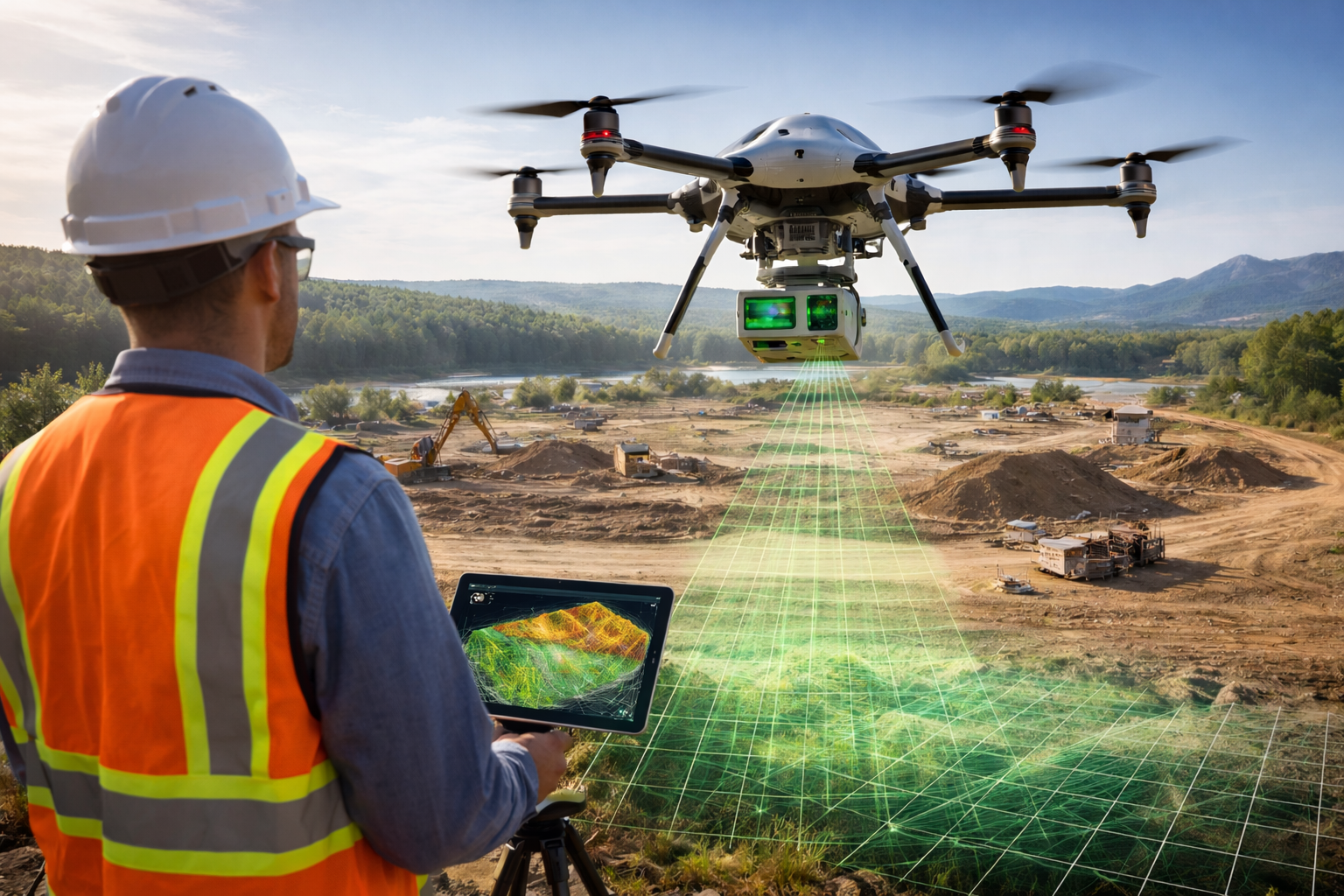
Integrating with the Matrice 400 and Beyond
DJI’s Matrice 400 series is the first platform built around the Manifold 3. The aircraft features an open architecture with SkyPort V3 and E‑Port V2 for quick payload mounting. A new payload bay houses the Manifold 3 and provides power and data connections. The drone uses O4 transmission to stream high‑definition video and control signals for up to 20 kilometres (12 miles), and built‑in mmWave radar helps avoid obstacles when visibility is poor. When combined, these systems create a robust platform for BVLOS (beyond visual line of sight) operations.
DJI Matrice 400 paired with Manifold 3 enables rapid field modeling, capturing 1 km² in 10 minutes with live preview and generating a 3D model in under 3 minutes ⏱ #djienterprise #manifold3 pic.twitter.com/yMHt0UHRvE
— DJI Enterprise (@DJIEnterprise) September 5, 2025
BVLOS Readiness and Regulations
Flying beyond line of sight used to be a regulatory barrier. That is changing fast. Global Market Insights notes that the autonomous BVLOS drone market was valued at USD 1.2 billion in 2024 and is expected to reach USD 11.6 billion by 2034, growing at a 25.9 % compound annual rate. One driving factor is advancements in AI and machine learning, which make drones more autonomous. Another is regulatory approvals. Authorities such as the Japan Civil Aviation Bureau (JCAB) and the UK Civil Aviation Authority (CAA) are crafting policies that allow BVLOS operations near critical infrastructure like power lines and wind turbines. This policy shift opens the door for drones equipped with the Manifold 3 to perform routine inspections without constant visual oversight.
Drone Docking and Remote Operations
The Manifold 3 pairs naturally with DJI Dock and other autonomous stations. In a typical setup, a drone sits in a weather‑proof dock, recharges between missions and launches autonomously when commanded. With the Manifold 3 running onboard AI, the drone can analyze weather, battery health and mission data before taking off. It can fly to a remote site, inspect assets using pre‑programmed routes and real‑time decision‑making, and return home, all without human intervention. When connected to a 4G or future 5G network, operators can monitor the mission from a control centre and intervene only when necessary. This reduces labour and allows for constant monitoring of pipelines, towers or solar farms.
Industry Use Cases That Benefit from Manifold 3
Utilities and Energy
Power companies need regular inspections of transmission towers, substations, wind turbines and solar arrays. Manual inspections are risky and time‑consuming. A drone equipped with Manifold 3 can fly near live high‑voltage lines, detect component wear, and transmit findings instantly. Such drones perform real‑time object detection, classification and custom AI analysis. They fuse thermal, visual and LiDAR data to spot overheating insulators or misaligned conductors. If the AI identifies corrosion, it can flag the exact coordinates and dispatch crews only where needed. For wind turbines, the drone maps blade surfaces, detects cracks and determines repair urgency. These insights help power companies reduce outages and maintenance costs.
Related Reading: Types Of Wind Turbine Blade Defects and What Causes Them
Oil and Gas Infrastructure
Industrial plants and pipelines stretch for hundreds of kilometres through remote areas. Autonomous drones with Manifold 3 can patrol these assets daily. Equipped with thermal cameras, they spot leaks in pipelines; using LiDAR, they detect structural deformation in flare stacks; with AI, they recognize corrosion patterns on tanks. By overlaying sensor data with 3D models, the system highlights anomalies for immediate action. The ability to operate in –20 °C to 50 °C and resist dust and moisture means it can handle desert oil fields or offshore rigs.
Construction and Surveying
Building large structures requires constant surveying and progress monitoring. Manifold 3 empowers drones to create 3D models and plan flight routes in real time. You can map a construction site with a LiDAR payload and then use the AR overlay to tag rebar positions or deliver material counts. On long projects, the drone returns regularly to update the 3D model, revealing where work has progressed or deviated. AI models detect cracks, measure stockpiles or count vehicles. Because the system processes data onboard, you get immediate metrics without waiting for cloud processing. This helps project managers make decisions faster and reduce rework.
Agriculture and Forestry
Farmers often struggle to monitor large fields. A Manifold 3‑equipped drone can fly autonomously over crops, using multispectral sensors to compute vegetation indices and highlight areas needing attention. Through real‑time edge computing, the drone can adjust its altitude or route based on crop height or weather. Forestry agencies can use similar setups to monitor forest density, track wildlife or assess fire risk. When combined with 4G connectivity, data streams back to agronomists in near real time, enabling quick decisions about irrigation or pest control. The ability to install custom apps means researchers can build specialized plant‑disease classifiers that run on the drone itself.
Public Safety and Emergency Response
When emergencies hit, you don’t have time to waste. A drone with the Manifold 3 can instantly process what it sees and give you clear updates for situational awareness. In a rescue mission, it can spot heat signatures of people hidden in rubble or forests. Fire crews can fly it over a wildfire, identify hotspots, and share AR overlays of escape routes.
The Matrice 400 adds sensors like mmWave radar that let it “see” through smoke or fog. In cities, it can scan buildings after an earthquake for dangerous cracks. Because everything runs on the drone itself, you don’t need to worry about patchy internet signals during a crisis.
Water and Environmental Monitoring
Keeping an eye on water systems is no easy job. Pipelines, rivers, and reservoirs all need regular checks. With the Manifold 3, drones can spot leaks by picking up unusual heat patterns or even noticing changes in nearby plants.
The onboard AI can go further—it can identify different plant types or algae and alert you if invasive species show up. Environmental teams can also use it to watch over wetlands or wildlife areas, catching illegal activity or shifts in land use early. And because the data is processed right on the drone, sensitive information stays private before it’s shared.
How to Deploy and Develop with Manifold 3
Preparing Your Drone
Installing a Manifold 3 on the Matrice 400 series involves connecting it via the E‑Port V2 or SkyPort V3. The module draws power from the drone and communicates via a high‑speed bus. A mounting bracket secures it beneath the payload bay, adding only about 120 g to the aircraft.Once installed, the drone recognizes it automatically. You can check system status in DJI Pilot 2 and update firmware over the air using a Wi‑Fi or 4G connection.
Developing AI Models
The Manifold 3 uses the NVIDIA JetPack and CUDA frameworks, familiar to developers working with Jetson hardware. You can train models on a workstation using PyTorch or TensorFlow and then convert them to TensorRT for optimized inference. DJI provides sample code and documentation for accessing sensors through PSDK and controlling the aircraft via Mobile SDK. Because the computer is powerful, you can run large models like YOLOv7, Mask R‑CNN or custom CNNs for classification. Start with existing models for object detection and gradually refine them using your own datasets.
Integrating with Existing Systems
For enterprise use, drones rarely operate in isolation. The Manifold 3’s 4G networking capability means you can connect it to corporate servers, SCADA systems or GIS databases. Using the Cloud API, you can send mission commands or receive data through MQTT or HTTP endpoints. The device supports remote application deployment, log collection and health monitoring. You can also record data locally on the 256 GB SSD and sync it when the drone docks. For redundancy, the system continues to record even if the network drops.
Are there limitations?
While Manifold 3 is a leap forward, it isn’t a panacea. Developers must manage thermal throttling if the ambient temperature exceeds 50 °C, although the IP55 design helps. Training and deploying AI models require technical expertise; poor models can produce false positives or miss critical defects. Regulations still restrict BVLOS operations in many countries, so you must secure permissions. Finally, not all sensors are plug‑and‑play; integration may require custom drivers or hardware modifications.
Related Reading: The FAA Wants BVLOS at Scale but Your Drone May Not Qualify
DJI’s Manifold 3 demonstrates how a small, rugged computer can transform a drone from a flying camera into an autonomous worker. By combining 100 TOPS of AI computing power with powerful environmental protection, open developer interfaces and cellular connectivity, the module helps drones see, think and decide in the field.
Industries from power to agriculture are leveraging this capability to inspect assets, monitor environments and respond to emergencies with minimal human oversight. The rapid growth of the BVLOS market signals that such systems will become the norm rather than the exception. If you want your drone operations to move from manual to autonomous, learning to harness the capabilities of Manifold 3 is a vital step.
FAQs on DJI Manifold 3 and Autonomous Drone Operations
What is the DJI Manifold 3?
The DJI Manifold 3 is a compact onboard computer designed for drones like the Matrice 400 series. It’s small in size but has the computing strength of a high-end laptop. With up to 100 trillion operations per second (TOPS), it lets drones process data, run AI models, and make real-time decisions during flight—without needing constant internet or cloud access.
Why does the Manifold 3 matter for drone operations?
It matters because it turns a drone from a remote-controlled camera into an intelligent aircraft. Instead of relying on human pilots for every move, drones with the Manifold 3 can analyze their environment, detect anomalies, and adjust flight paths in real time. That saves time, increases safety, and makes drones reliable for demanding missions like inspections or emergency response.
Can developers build custom applications on Manifold 3?
Yes, absolutely. The device supports DJI’s SDKs (Payload SDK, Mobile SDK, and Cloud API), so developers can access raw data, plug in third-party sensors, and write their own applications. Whether it’s custom AI for crop disease detection or specialized inspection software for wind turbines, you can run those models directly on the drone.
How does the Manifold 3 improve autonomy?
It improves autonomy by letting drones see, process, and act instantly. The onboard AI can identify objects like damaged insulators, cracks on turbine blades, or lost hikers in thermal images. It then triggers smart responses—zooming in, changing course, or logging precise coordinates—without waiting for human input.
Can Manifold 3 support 3D mapping and route planning?
Yes. The Manifold 3 powers features like Smart 3D Explore, which lets drones map an area and plan inspection routes in the same flight. That means you can capture a site, generate a 3D model, and then plan a close inspection path without starting a new mission.
Does it work with augmented reality (AR) overlays?
It does. In DJI Pilot 2, the Manifold 3 enables AR overlays on live video. That means when inspecting a tower, you can see part labels or maintenance history directly on the screen. For agriculture, you can view vegetation health indices while flying over fields.
How does the Manifold 3 help with BVLOS operations?
By processing sensor data and making autonomous decisions, the Manifold 3 reduces the need for constant human oversight. Regulators in places like Japan and the UK are beginning to allow beyond visual line of sight (BVLOS) flights for critical infrastructure inspections, and Manifold 3 helps drones operate safely under those conditions.
Can it be paired with drone docks?
Yes. Manifold 3 pairs perfectly with DJI Dock systems. The drone can sit in a dock, recharge, and autonomously launch when commanded. With onboard AI, it checks weather, battery health, and mission data before flying, then performs inspections and returns—without anyone on-site.
Is it complicated to install on a drone?
Not really. On the Matrice 400, the Manifold 3 connects through DJI’s ports and mounts under the payload bay. The drone recognizes it automatically, and you can monitor its status in DJI Pilot 2.
What software frameworks does it support for AI models?
It works with NVIDIA JetPack, CUDA, TensorRT, and common AI frameworks like PyTorch and TensorFlow. That means you can train a model on your workstation and then optimize it to run directly on the drone.
Can it connect to external business systems?
Yes. With 4G networking and DJI Cloud API, the Manifold 3 can send mission data to corporate servers, SCADA systems, or GIS platforms. You can also store data locally on its 256 GB SSD and sync it later.
What are the main limitations of the Manifold 3?
There are a few. If temperatures exceed 50 °C, the system may throttle. AI models need to be well-trained to avoid errors. BVLOS rules are still restrictive in many regions, so permissions are required. And some advanced sensors may need extra integration work.


